
Home » Collector — field supervision on the drawings
Collector: the drawings, the tasks and the evidence, on site
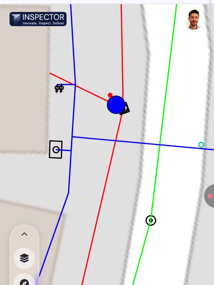
Collector is the field half of Inspector. It runs on a phone or a tablet and shows the crew the current drawings on a map, with their own position on it.
Everything recorded in the field lands on the same project as the quantities and the budget, tied to a location, so the office is looking at the site rather than at a description of it.
Finding your way around the design
A site engineer standing in a trench needs to know what is supposed to be there. Collector puts the approved drawings on a map with the layers switched on and off as needed, and shows where you are standing on them, to GPS accuracy, or to centimetre accuracy with an RTK antenna.
That single capability removes a category of error that costs real money: work built off a superseded revision, or in the wrong place.
Tasks pinned to a place
A task in Collector is created on the map. It carries a location, photos, voice notes and a status, and it belongs to a discipline and a phase. Assign it to a subcontractor and they see it on their own device.
Because tasks and quantities sit in the same project, progress reporting stops being a separate exercise. What was recorded as done in the field is what feeds the report.
Reports the client will accept
Report forms are configurable: daily logs, supervision reports, safety inspections, delivery notes, quality checks, handover checklists. You define the fields, the lists and who fills what.
Output is Excel or PDF, carrying the current field data and the photographic evidence behind it, and it can be issued under the client’s own branding.

Handover and defects
At handover the checklist is built for the type of work and the elements that have to be checked. Defects and outstanding items are recorded against a location or an element, so the list that goes back to the contractor is specific rather than a general complaint.

Frequently asked questions
What does it run on?
Any phone or tablet, iOS or Android, through the browser. There is nothing to install and no dedicated hardware, and the same account works on a desktop in the office.
Does it work without a signal?
The map and the drawings stay available in the field, and records made without a connection sync when one comes back. Sites with no reception are the normal case in infrastructure work, not the exception.
How accurate is the positioning?
Standard phone GPS is enough for orientation and for pinning a task. Where centimetre accuracy is needed, Collector pairs with an RTK antenna, which is how it is used for measurements that feed a payment application.
Can subcontractors use it?
Yes. Permissions are split by team, contractor or project phase, so a subcontractor sees their own tasks and drawings and nothing else.
Can we build our own report forms?
Yes. Forms are built from field types you configure: text, lists, numbers, dates, photos, signatures, and roles for who fills each part. Existing paper or Word forms can be rebuilt as Collector forms.
How does it connect to the quantities side?
They are the same project. The quantities derived from the design files and the records made in the field sit on one map, which is what makes it possible to compare what was claimed against what the drawings support and what the site shows.